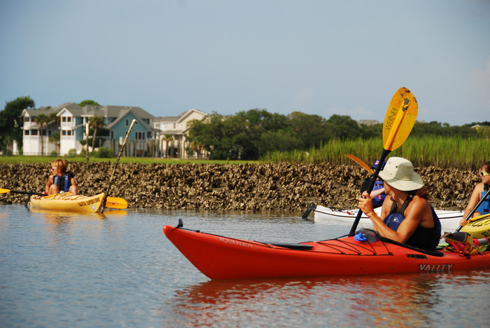
South Carolina's coastal waterways offer easy connections between some of our state's most beautiful areas. Now the S.C. Department of Natural Resources has made paddling between these locations, cities, and towns even easier.
Our state's "Southeast Coast Saltwater Paddling Trail" extends 295 miles from the Savannah River at the Georgia border through the Sea Islands, past Charleston, along the Grand Strand, and ends at Little River on the North Carolina border. A map showing points of interest, along with simple to copy latitude/longitude coordinates for the entire trail is free on the DNR website.
The DNR writes:
Get detailed information about public properties throughout the Carolina coast, copy and paste GPS coordinates into your favorite device or online map and there are even photo galleries for many of the points of interest along the way.
The section offers a paddling trail with a diversity of natural and cultural features, and includes every South Carolina coastal habitat type, from tidal waters, marshlands, and swamps to barrier islands, dunes, and beaches. Many cultural sites and places of interest are accessible by kayak including old forts, plantations, fishing villages, port cities, resorts, and many protected wildlife areas.
You can view the resource over here, and a table with distance segments and links is below.
| 1 | Savannah River, Georgia Border | Beaufort | Savannah River, Cooper River, Mackays Creek, Port Royal Sound, Beaufort River, Coosaw River | 60 |
| 2 | Beaufort | Edisto Island, the ACE Basin | Morgan River, St. Helena Sound, Ashepoo River, South Edisto River, Dawho River | 30 |
| 3 | Edisto Island | Charleston | North Edisto River, Wadmalaw River, Stono River, Elliot Cut, Wappoo Cut, Charleston Harbor | 50 |
| 4 | Charleston | McClellanville | Charleston Harbor, Intracoastal Waterway, Bulls Bay | 50 |
| 5 | McClellanville | Winyah Bay at Georgetown | South Santee River, Intracoastal Waterway, North Santee River, Esterville Minim Creek Canal, Winyah Bay | 40 |
| 6 | Georgetown | Sacastee, lower Pee Dee and Waccamaw | Great Pee Dee River, Waccamaw River, Intracoastal Waterway | 30 |
| 7 | Socastee | Little River, Intracoastal Waterway at North Carolina Border | Little River, Intracoastal Waterway | 35 |
| Approximate Total Distance in Miles | 295 | |||
Filed in
Comments
Packers and Movers Hyderabad
Packers and Movers Mumbai
Packers and Movers Chennai
thanks Rocky Handsome Box
great work Bigg Boss 10
great work doings Written
great work doings Written Update
awesome work Tattoos Designs
awesome work Tattoos Designs for Women
I recently came across your
I recently came across your article and have been reading along. I want to express my admiration of your writing skill and ability to make readers read from the beginning to the end. I would like to read newer posts and to share my thoughts with you, Jual Alat Sex
Pretty Love Brighty
Article written is very well
Article written is very well href="http://www.shareitforpcdownload.com/shareit-for-pc-download-for-windows-7-10-8-8-1/">SHareit Lyrics Funny Status & StatusThanks for that article..
You article is describe in a
You article is describe in a good manners with best possible way and now I am follow your site on daily basis and I like a very much your blog, so keep posting with such a nice article and we are also write something about Indian festival if anyone interested them, so checkout link all
Eid Mubarak Images
Eid Mubarak 2016
Friendship Day Images
Happy Dussehra Images
Happy Navratri Images
Independence Day Images
Raksha Bandhan Images
Happy Diwali Images
Happy Teachers Day Quotes Wishes
Happy 4th of July Images Quotes
Happy Fathers Day 2016
Happy Fathers Day
Thanks for this awesome
Thanks for this awesome webpage that you have. I like to read your post
wonderful post it was great
wonderful post it was great iphone 7 cases thanks
good post
Your work is great and I
Your work is great and I welcome you and jumping for some more enlightening posts. Much obliged to you for sharing extraordinary data to us.
Pregnancy Miracle
Thanks for the information.
Thanks for the information.
buy instagram likes cheap
free instagram followers


Really impressed! Everything is very open and very clear clarification of issues. It contains truly facts. Your website is very valuable. Thanks for sharing. do my paper for cheap