Image by National Weather ServiceImage by 20090826-danny.jpg
Update August 27: Check out our updated report.
Update August 26: As of the 5 p.m. forecast update, Danny's path still remains largely uncertain.
From the National Hurricane Center:
This evolution should cause Danny to turn northward and then recurve into the westerlies. ...
While the models agree on the scenario...there is still significant uncertainty as to what land area Danny may affect. ... Overall..the guidance envelope has shifted slightly to the east since the last advisory.
This storm largely appears to be a wait-and-see one.
We'll keep you posted.
First reporting:
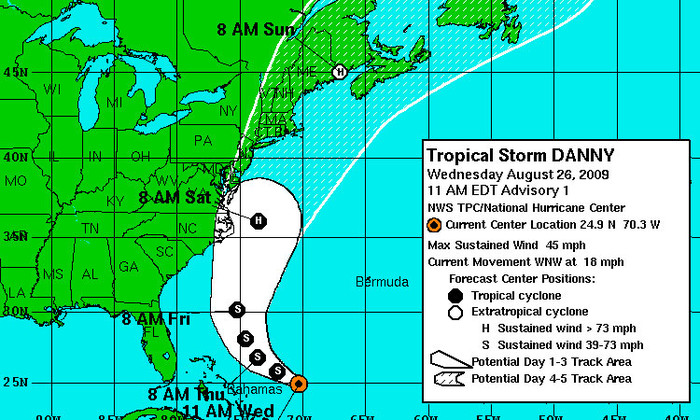
The National Hurricane center has confirmed the formation of Tropical Storm Danny.
The storm is packing 45 MPH winds and is moving west-northwest at 18.
We’ll need to watch this as it stands to come fairly close to the Southeast coast by this weekend. The forecast calls for a Category 1 Hurricane Danny to come very close to the Outer Banks of North Carolina Saturday morning.
This can and likely will change as time goes on, so we’ll be keeping a close watch. Stay tuned.
You can get the latest information over at Charleston Weather's blog or TheDigitel's hurricane page.


