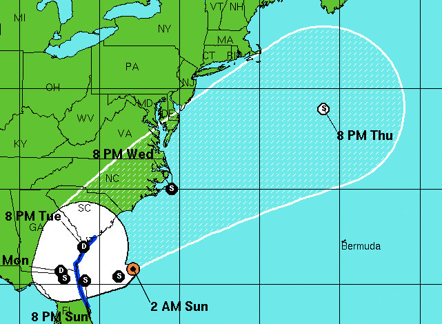
Image by NOAA Beryl's forecast as of 2 a.m. on Sunday with max sustained winds of 50 mph.
Update: Get the update here.
Subtropical Storm Beryl continues to drift southwest towards making landfall near Jacksonville, Florida, however Lowcountry residents should get ready for rain and high winds, particularly if the storm drifts more westward.
Beryl is expected to make landfall in the early morning hours on Monday, and the Lowcountry currently is being given a 40% chance of bringing tropical storm-force winds throughout the Charleston area.
The storm also presents a double chance for rainfall as it is expected for it to turn north:
Beryl is moving southwestward as a strong ridge develops to its northwest over the Eastern United States. The models forecast this ridge to move eastward during the next 36 hours and then weaken it as a large deep-layer trough moves eastward from the central United States. This evolution should cause Beryl to turn westward and make landfall in the southeastern United States between 24-36 hours. After that time the track guidance agrees that the cyclone will stall and then turn northeastward.
With a good chance of high winds and this being the second storm to approach the Carolina coast even before the start of the hurricane season, residents are well advised to begin prepping their homes, hurricane supplies, and evacuation plans. — You can check out our guide here.