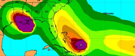
Image by National Weather ServiceImage by 20080901winds.jpg The forecast means: Stay alert Charleston for big waves, rains, and winds. More intense colors mean a greater likelihood an area will see tropical storm-force winds. Left is Gustav, middle is Hanna, right is what could be Ike.
Update 11 p.m.: Hurricane Hanna's forecast trajectory has continued to move up the coast and now points at Charleston. The storm's still several days away, so we'll have to wait and see.
Update 5 p.m.: Tropical depression nine is now Tropical Storm Ike. We'll keep you posted.
Update 12 p.m.: Tropical depression number nine has formed and is taking aim at the Bahamas. It's expected to become Tropical Storm Ike over the next several hours.
Prepare yourself for "I [don't] like Ike" jokes.
Original post: There's a lot of activity in the Atlantic at the moment, we do a roundup.
Hanna's path is starting to take shape, and seems to be moving up the coast towards Charleston. But the storm wouldn't hit until Friday night, making it far too early to tell for sure where it will go.
So, follow Hanna's forecast at The National Weather Service and The Weather Underground.
Regardless of where Hanna goes, it's almost certain our waves will get big. Though they're measuring "only" 3-5 feet now they're forecast to hit 15 feet by Friday. But, again, this depends on where the storm goes.
And though New Orleans dodges Gustav's not-as-bad-as-expected brunt, things are still busy, busy in the Atlantic with four other areas being watched for cyclonic activity (read: possible hurricanes).


