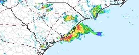
Image by National Weather ServiceImage by 20080620rain.jpg Map shows the "base reflectivity," an important measure of rainfall. The intensest colors represent rainfall of up to 16 inches and hour. Map generated at 6:27 p.m.
Update: The main part of the storm seems to have moved out, but forecasters expect some lightning strikes and other possible storm conditions to continue through the night.
The National Weather Service has issued a severe thunderstorm watch through 9 p.m. Large hail, thunderstorms, funnel clouds, wind gusts of 60-plus mph and flash flooding are possibilities. Caution is recommended. Watch for links and updates as they come.
Thousands of power outages are being reported in the Charleston area. The majority of which are west of I-526 in West Ashley. As of 6:27 p.m. there were 5,407 outages reported in the Charleston area.
From their forecast:
Scattered showers and thunderstorms, mainly before 2am. Some storms could be severe, with large hail and damaging winds.
From their discussion:
.near term /through tonight/...the storm prediction center has issued severe thunderstorm watch585 for parts of southern south carolina in effect until 9 pm edt. Significant instability and deep layer shear will combine to create an environment favorable for strong to severe thunderstorms the rest of the afternoon into this evening with large hail...damaging winds and tornadoes possible. most of the activity should remain n of interstate 16 in GA. The strongest convection should diminish this evening due tonight time stabilization. however...cannot rule out some lingering activity as was seen last night. thus...have maintained 20 pops overnight...mainly across sc which will be closer to the weak warm front extending from the area of low pressure near augusta.
The Post and Courier reports:
The National Weather Service said someone reported seeing a funnel cloud on Johns Island, but there was no confirmation.
Meteorologists said it would not be confirmed unless damage was reported and surveyed.
Some useful links:
- View a map of total rainfall
- Report a power outage: 1-888-333-4465 (streetlights and outdoor lighting: 1-800-251-7234)
- SCE&G's mobile Web page
- SCE&G's storm tips
- Area traffic cameras