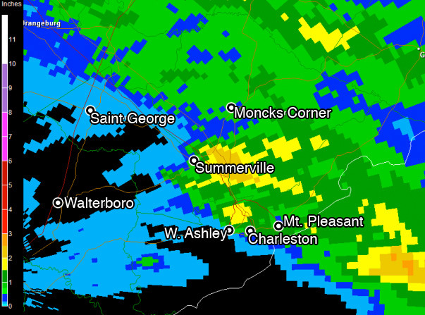
Image by National Weather Service RADAR (image generated by GRLevel3)Image by 20090717weather.jpg RADAR-estimated rainfall totals up until midnight July 17. Blue areas show trace amounts, while yellow and orange show respectively higher amounts of rain -- up to 3 inches.
Slow-moving thunderstorms brought a little bluster and a whole lot of rain to the Charleston area this evening, dumping upwards of three inches of rain in some spots, and leaving roads covered.
Read more stories on this subject in our weather topic page.The thunderstorms made their presence felt first through strong winds -- a peak gust of 53 MPH being recorded at Pineville in Berkeley County -- and gradually began to slow up to dump an estimated 3" of rain in some portions of North Charleston into Summerville.
There were several flood reports, including flooding near Northwoods Mall with water approaching car doors. The rain traversed southeastward into downtown, where Charleston tweeter Joe Keith reported white capping on East Bay Street near Harris Teeter. The storm's final act? A lightning strike in Mt. Pleasant and plenty of scattered power outages throughout the region.
Iowa Environmental Mesonet provides an excellent Google Map and table of this evening's official storm reports.
More to come?
Forecasters hold a 50% chance of showers and thunderstorms, with the chance for an isolated severe thunderstorm, in Friday's forecast, so don't be too quick to put away your umbrella. Rain chances will stick with us on Saturday, abate a bit on Sunday, and then be with us through a great deal of next week.