Jared Smith
Points: 0
Region:
Region:
Recent posts
7:53 pm on Friday August 6, 2010
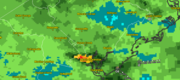
Severe weather rocks Charleston Friday; Track storm damage reports
Image by National Weather Service/weatherTAP.com Estimated total rainfall, cherry red indicates five inches, and darker shades of green indicate 2-2.5 inches. View the image bigger here. Data is for the thunderstorms on August 6, image taken at 10:...

1:36 pm on Monday August 2, 2010
Learn to make Charleston weather reports even better at this spotter class
Image by National Weather Service The National Weather Service Skywarn logo.
If you're interested in the weather and want to be able to help the National Weather Service do its job better, don't miss this opportunity: NWS Charleston and WCBD's Storm...
12:02 pm on Tuesday December 1, 2009
Storm to bring coastal flooding, threat for severe weather Wednesday
Image by Flickr user almazuk
Update December 2:
Here's updated info on the storm.
First reporting:
A potent storm system is expected to make a rough go of Wednesday in the Charleston area.
National Weather Service Charleston has placed the coastal...
8:15 am on Wednesday July 22, 2009
Watch for road flooding tonight
There's a coastal flood advisory from 7 to 11 this evening for Isle of Palms, Sullivans Island, Downtown, Folly Beach, and surrounding locations.
The flooding is not expected due to rain, but from a combination of astronomical factors and an onshore...
3:13 am on Friday July 17, 2009
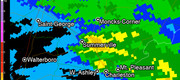
Strong thunderstorms soak Charleston; Bit more on way
Image by National Weather Service RADAR (image generated by GRLevel3)Image by 20090717weather.jpg RADAR-estimated rainfall totals up until midnight July 17. Blue areas show trace amounts, while yellow and orange show respectively higher amounts of...